Mining and Exploration
At Southern Geophysical, we specialise in diverse geophysical methods for mining and mineral exploration
Seismic Reflection
The requirements of exploration for oil, gas and coal are varied, and depend on the size and depth of the target, the material properties of the overburden and the terrain being explored. We are experienced in designing and implementing seismic surveys and are well-practiced in meeting the unique challenges of exploring New Zealand’s backcountry.
We offer both 2D and 3D seismic reflection surveys to image basin structure and stratigraphy. We can acquire both P-wave seismic reflection for on land targets (down to 1km), as well as higher resolution P-wave and S-wave surveys for coal and other stratabound deposits nearer the surface (50-300m).
Imaging contacts, horizons, and faults with 3-5m thickness and offsets is possible with good survey design, high-quality acquisition and careful processing. Typical applications include elucidating deep basin-scale geology, identifying small-medium scale structure for geological modelling, highwall design and mine planning. Data is inverted to depth domain for ready inclusion into your geological model.
Seismic Refraction Tomography (SRT)
Seismic refraction tomography (SRT): is useful for imaging depth to horizons and lithological changes to depths of around 50m.
Ground Penetrating Radar (GPR)
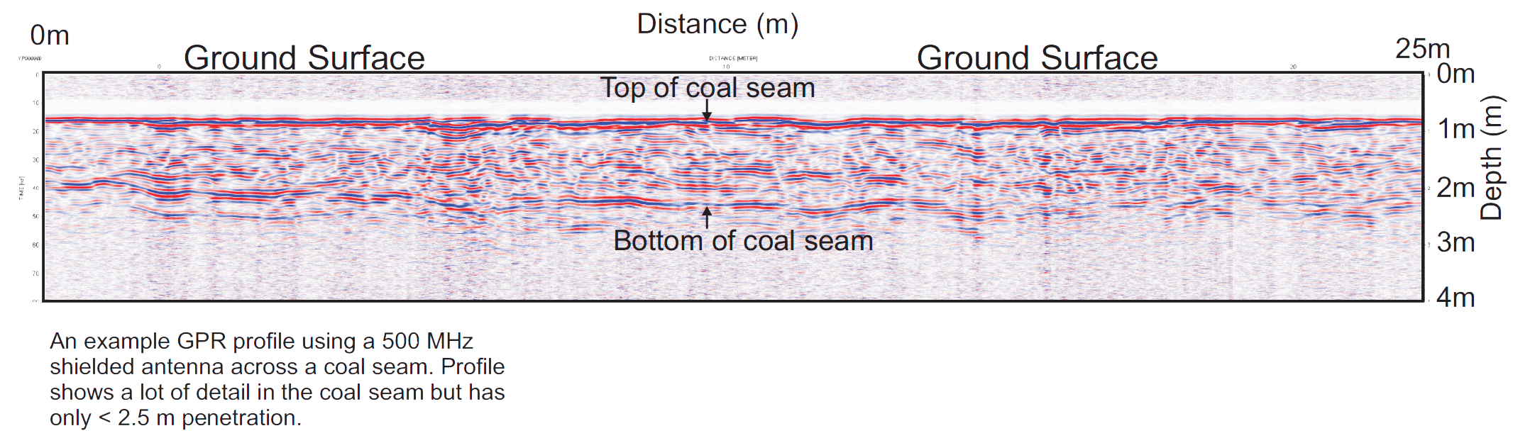
Southern Geophysical own and operate New Zealand’s largest range of antennas (100 – 2,700 MHz) for surveying targets ranging in depth between 10mm down to 25m. delineating and mapping the extent of overburden in gravelly soils. We can determine the thickness and 3D structure of individual gravel layers allowing forward planning and site development to be undertaken at much lower cost than traditional intrusive investigations.
GPR can be used to determine the thickness and continuity of beach sands, river channels and gravel lags that may be host to alluvial gold and other mineral sands. It can also detect coal seams and mine voids in the subsurface.
Electrical Resistivity Tomography and Induced Polarisation
ERT/IP): these complementary techniques can be used to detect sulphide mineralisation and the presence of burnt coal seams.
Find out more
Multi-channel Analysis of Surface Waves (MASW)
Multi-channel Analysis of Surface Waves (MASW): can be useful for identifying changes in stratigraphy and lithology across a site and depth to bedrock.
Find out more
Magnetics and Gravity
Large scale structure and basin studies.
Find out more
Bedrock Profiling
Subject to the depth of the interest and technical constraints, we can carry out a bedrock survey using one or more of the following techniques - GPR, seismic, and MASW. Selection of the best method is a case-by-case decision. Applications include determining overburden depth across quarries, the depth and sedimentary structure of placer deposits, locating historic mine voids, depth of dredging and the extent of old backfill across a site. Find out more


