Bedrock Profiling
Southern Geophysical specialises in bedrock profiling utilising GPR, seismic refraction tomography, and MASW for detailed subsurface imaging
Profiling the depth to rock across a site, in either 2D or 3D space, is a common engineering requirement. Often geological mapping or intrusive investigations provide inconclusive results with dip directions, incised channels, faults, and other features poorly constrained. Geophysical methods can provide rapid and cost-effective means of imaging the substrate to connect the dots between intrusive tests or surface outcrops.
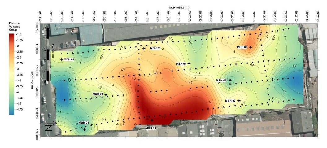
Depending on the depth of the rock at the site, Southern Geophysical has the expertise to carry out a geophysical survey using one or more of the following methods: GPR, MASW, Seismic Refraction Tomography, and Seismic Reflection.
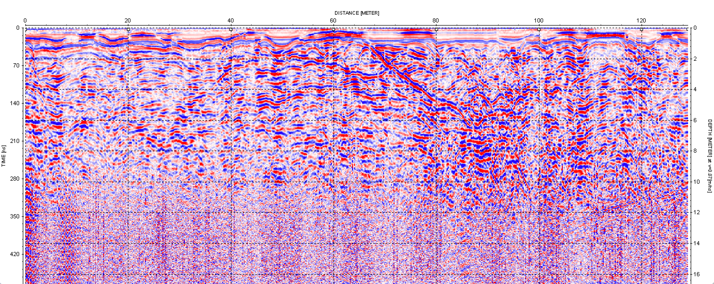
GPR (Ground Penetrating Radar)
GPR is one of the simplest methods to deploy and operate. An enclosed unit containing two antenna is towed or pulled along the ground with an attached odometer wheel and an acquisition computer. A range of antenna are available, which transmit at different frequencies. Southern Geophysical's highest frequency antenna, 2.7 GHz, is useful for imaging concrete structures to very high resolution but only penetrates to 0.5 m below the surface. At the other end of the spectrum is our 100 MHz system, which provides a lower resolution but depth penetration in the range of 6 m to 20 m below the surface.
The output from GPR is an image of the substrate based on changes in dielectric permittivity. It is the highest resolution method available for imaging the subsurface. For this reason, GPR is often used as a reconnaissance method prior to deploying more involved geophysical systems. Depth penetration with GPR depends on the conductivity of the subsurface, with excellent penetration through low conductivity material such as clean gravels, and poor penetration through high conductivity, clayey materials. GPR does not provide any engineering properties of the clayey materials or any engineering properties of the subsurface.
Seismic Refraction Tomography
Seismic Refraction Tomography uses refracted P-wave energy to image subsurface horizons such as bedrock and water tables. The field set up requires deploying an array of geophones and seismic cables along a line, and generating point sources of seismic energy at set intervals along the line. The P-wave travel paths are recorded by a seismograph system. The point source of energy is normally a sledgehammer striking a metal plate, but depending on the depth required and the length of the refraction line an Accelerated Weight Drop (AWD) or explosives can also be used.
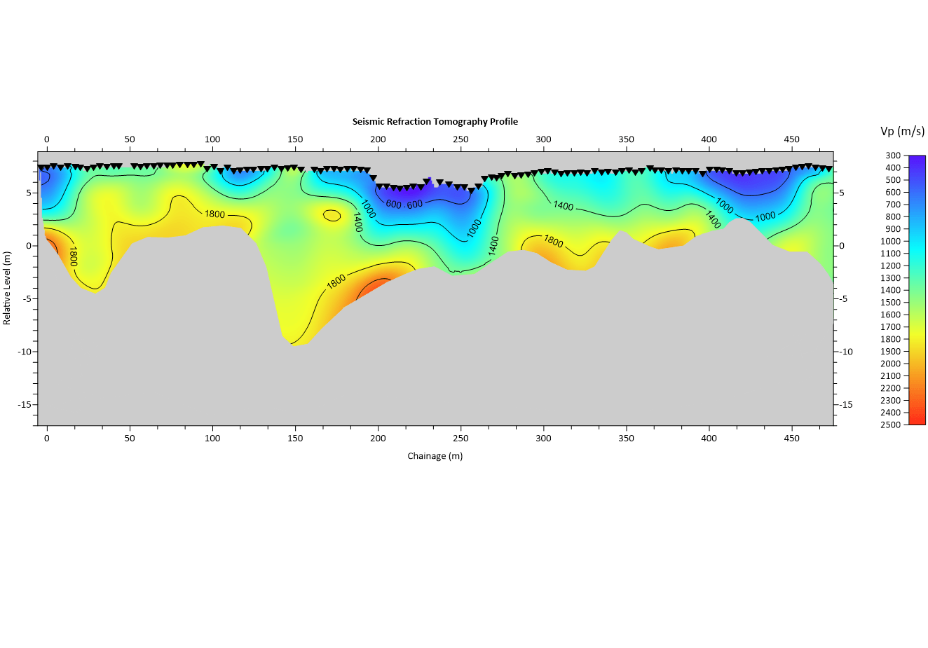
The output from seismic refraction is a cross-sectional image showing P-wave velocity variations with depth. If borehole logs or other intrusive data are available, the P-wave velocity contours can be correlated with lithological boundaries.
MASW (Multi-Channel Analysis of Surface Waves)
MASW uses a similar field setup to seismic refraction, with an array of geophones deployed and seismic energy recorded using a point source of energy. The length of the seismic array for MASW tends to be shorter (generally 24 m), and the system uses lower frequency geophones. MASW data can be acquired using a fixed array, or a towable array of geophones. MASW is highly flexible in how it can be deployed in the field and how data is acquired. A typical survey involves using a towed array to collect a series of data points along a transect.
The analysis of MASW data takes the surface wave energy from the seismic data, models the propagation velocities of the surface waves, and runs inversions to produce shear-wave velocity models. If a line was surveyed with a series of data points, each of those data points can be interpolated together to produce a cross-sectional image of shear-wave velocities with depth. If the velocity or depth of a horizon at a certain point along the line is known, geological interpretations can be added to the MASW section.


